The RDF Calculator was primarily written for radio-direction finding. It can be used to calculate and visualize the intersection from the beam heading of two observers to find the location of an unknown transmitter.
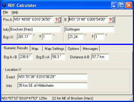
The positions of the two observers can be selected from a city database, or entered in the program by latitude and longitude. Next, enter the directions (headings) for both stations towards the unknown transmitter are entered in the upper part of the window ("Bearing to location X"). If the antenna beam widths are known, they can also be entered in the upper part (the beam widths are also important for the map display). The program will then calculate the center coordinate of the intersection of both beams, and show the result in numeric form:
The numeric result tab shows the bearing ("beam heading") between the two observers A and B.
In addition to the numeric results (shown above), the program will also draw both observers, the beam paths, and the intersection ("location X") on a simple map. The beams from observer A and B are displayed as hatched areas in the map. The intersection area of both beams depends on the antenna aperture angles, which (if known) can be entered in the fields right next to the bearing input fields ("+/- 1 degrees" are the default settings, not too realistic for VHF or UHF antennas). At least this can give you a coarse estimation about the accuracy you can expect from your radio direction finding tests.
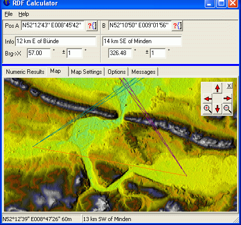
The map can show cities, coastlines, borders, rivers, and optionally the topographic relief if you have the GTOPO30 or SRTM3 topographic database on your system - details in one of the next chapters. Please note that the "topographic view" can only be enabled if you have installed one of these databases for your area !
Alternatively, the RDF calculator can be controlled from other programs - see chapter 'Remote Control' further below. For example, the author's program Spectrum Lab can periodically send the antenna beam heading to the RDF calculator. The direction of arrival is calculated by Spectrum Lab (in RDF mode), and the result is displayed in the map by the RDF calculator.
For legal reasons (and size limitations) the topographic databases, i.e. files with elevation data, are not part of the installation package of the RDF calculator. Instead, you must download the database for your part of the world from one of the links shown further below in this chapter.
The RDF calculator can use either GTOPO30 files (*.dem) or STRM3 files (*.hgt), but not both at the same time. The GTOPO30 database has a resolution of 30 arc seconds, or ~ 1 km. For detailed maps covering smaller areas, use the SRTM3 database (Shuttle Radar Topography Mission) with 3 arc seconds per 'pixel', or about 90 meters resolution.
The GTOPO- or SRTM databases are split up into single "tiles", covering square or rectangular areas. Each "tile" can be downloaded as a files, and uncompressed (unzipped) using a good file manager like "Total Commander", formerly known as "Windows Commander", which can unpack zipped or UNIX-compressed files easily (just as if it was an ordinary subdirectory). Note that the RDF calculator can only handle uncompressed files (*.dem for GTOPO30, or *.hgt for SRTM3) .
For example, if you are in western Europe and want to use the GTOPO30 database, there should be at least one file like this in a certain folder:
c:\gtopo30\w020n90.dem (57.6 Megabytes in a single file).
All other files in the gzip'd GTOPO30 archive are not required by the current version of the RDF calculator, but they may be important for other mapping applications which also use the GTOPO 30 database. So in case of doubt, don't erase those *.src, *.stx, *.sch, *.prd, *.hdr and *.dmw files.
If you decide to install the GTOPO30 database into a different directory (instead of the recommended location C:\gtopo30), modify the configuration of the RDF calculator (on the OPTIONS tab, panel "Directories").
If you have multiple hard disks in your system, install the topographic map
database on the fastest harddisk -or even a RAMDISK- to speed up drawing
the map.
On this occasion: You can stop the map-drawing subroutine by pressing ESCAPE.
Parts of the GTOPO30 database can (or at least could) be downloaded from
http://edc.usgs.gov/products/elevation/gtopo30/gtopo30.html .
For western Europe, you only need to download the file w020n90.tar.gz . This is a unix-style compressed archive. You must unpack into the directory c:\gtopo30 on your harddisk; create this directory manually).
In December 2009, parts of the SRTM3 database cold be found at
http://dds.cr.usgs.gov/srtm/version2_1/SRTM3/Eurasia/ (etc, look for your continent in the parent directory if necessary) .
Each SRTM3 tile (file) covers an area of 1 by 1 degree. Details about the file format, and how they were generated used to be here:
http://dds.cr.usgs.gov/srtm/What_are_these.pdf
Finally, more details about NASA's SRTM mission is here: http://www2.jpl.nasa.gov/srtm/ .
First define WHAT you want to see on the map: Open the tabsheet "Map Settings".
On the "MAP SETTINGS" panel you can ...
Use the "OPTION" panel to ...
The small "navigator" panel in the upper right corner of the map can be used
to pan around, and zoom in/out. The map can alternatively be scrolled with
the cursor keys. If you don't need the "navigator", close it. It can be opened
again (if necessary) on the MAP SETTINGS panel.
The coordinate of the mouse pointer is displayed on the lower edge of the
window. If one of the topograhic databases is installed, the elevation above
sea level is also displayed.
The RDF Calculator's map display can also be used by other applications (especially those which shall run on PCs without internet connection..).
Remote control client (=external application) and server (=the RDF calculator) communincate via WM_COPYDATA messages, as explained here (external link).
The remote control commands use simple command strings. At the time of this writing, the following commands were implemented in the RDF calculator:
set brg1x=<RDF bearing from observer 1>
set brg2x=<RDF bearing from observer 1>
track addpoint <track point parameters>
track addpoint lat=+52.12345 lon=+8.54321 masl=120.5 kmh=120.0
track segment [name="<New segment name>"] [color=<new track
    colour>]
lat= <latitude in degrees, east positive, west negative>

    lon= <longitude in degrees, north positive, south negative>

    masl= < meters above sea level >

    kmh= < GPS velocity in kilometers per hour >

    udts= < Unix date and time in seconds
    (*) >

    hdop= < horizontal dilution of precision > ( a GPS quality indicator
    )

    nsats= < number of satellites currently used by a GPS receiver
    >
(*) "Unix date and time" as a floating point value, number of seconds elapsed since 1970-01-01 00:00:00 UTC.
This software is provided "AS IS" and without any express or implied warranties, including, without limitation, the implied warranties of merchantability and fitness for a particular purpose.
IN NO EVENT SHALL THE AUTHOR AND CONTRIBUTORS BE
LIABLE FOR ANY DIRECT, INDIRECT, INCIDENTAL,
SPECIAL, EXEMPLARY, OR CONSEQUENTIAL DAMAGES
(INCLUDING, BUT NOT LIMITED TO, PROCUREMENT OF
SUBSTITUTE GOODS OR SERVICES; LOSS OF USE, DATA,
OR PROFITS; OR BUSINESS INTERRUPTION)
HOWEVER CAUSED AND ON ANY THEORY OF LIABILITY,
WHETHER IN CONTRACT, STRICT LIABILITY, OR TORT
(INCLUDING NEGLIGENCE OR OTHERWISE)
ARISING IN ANY WAY OUT OF THE USE OF THIS SOFTWARE,
EVEN IF ADVISED OF THE POSSIBILITY OF SUCH DAMAGE.
IF YOUR LOCALITY DOES NOT ALLOW THESE WARRANTY CONDITIONS,
YOU ARE NOT GRANTED PERMISSION TO USE THIS SOFTWARE .
This software is FREEWARE. It is not in the Public Domain (yet).
The author (Wolfgang Buescher, DL4YHF) retains the copyright for this work.
Use it, modify it, but don't claim it for your own or charge others money
for it other than the cost of the media to deliver it.
Use at your own risk. It is provided for your enjoyment and neither the author nor contributors provide any warranty for it.
Last modified (YYYY-MM-DD): 2010-07-10