National Weather
Service Radars
And Other Weather Related Maps
|
Quick Jump to Certain
Radars.
Click it's Avalable Range's  Button Button
|
|
|
|
Location
|
Call
Sign
|
Long
Range
|
Short
Range
|
| Charleston, West
Virginia |
KRLX
|
|
|
| Blacksburg,
Virginia |
KFCX
|
- |
|
| Knoxville,
Tennessee |
KMRX
|
|
|
| Jackson,
Kentucky |
KJKL
|
|
|
| Louisville,
Kentucky |
KLVX
|
|
|
| Cincinnati, Ohio |
KILN
|
|
|
| Cleveland, Ohio |
KCLE
|
|
|
| Pittsburgh,
Pennsylvania |
KPBZ
|
-
|
|
| Sterling,
Virginia |
KLWX
|
-
|
|
Other Maps
Scroll on down to
the Lightning Detector Clickable
Link!
|
Charleston,
West Virginia
NWS's Call Sign : KRLX
Long Range

Short Range

|
Blacksburg,
Virginia
NWS's Call Sign : KFCX
Short Range

|
Knoxville,
Tennessee
NWS's Call Sign : KMRX
Long Range

Short Range

|
Jackson,
Kentucky
NWS's Call Sign : KJKL
Long Range

Short Range

|
Louisville,
Kentucky
NWS's Call Sign : KLVX
Long
Range

Short Range

|
Cincinatti,
Ohio
NWS's Call Sign : KILN
Long Range

Short Range

|
Cleveland,
Ohio
NWS's Call Sign : KCLE
Long Range

Short Range

|
Pittsburgh,
Pennsylvania
NWS's Call Sign : KPBZ
Short Range

|
Sterling,
Virginia
NWS's Call Sign : KLWX
Short Range

|

National
Map
|

Great
Lakes Regional Map
|
|
Geosyncronics
Orbit Image
Click to see the 5000x3000 pixel size!

|

Click to go to
the SPC Mesoanalysis Page
|

Watches and
Warnings Map
|
Storm
Prediction Report
|

|
This clickable
map leads to where pleminare
severe weather damage report is
located for today!!
|
| Convective
Outlooks |

Day 1
|

Day 2
|

Day 3
|
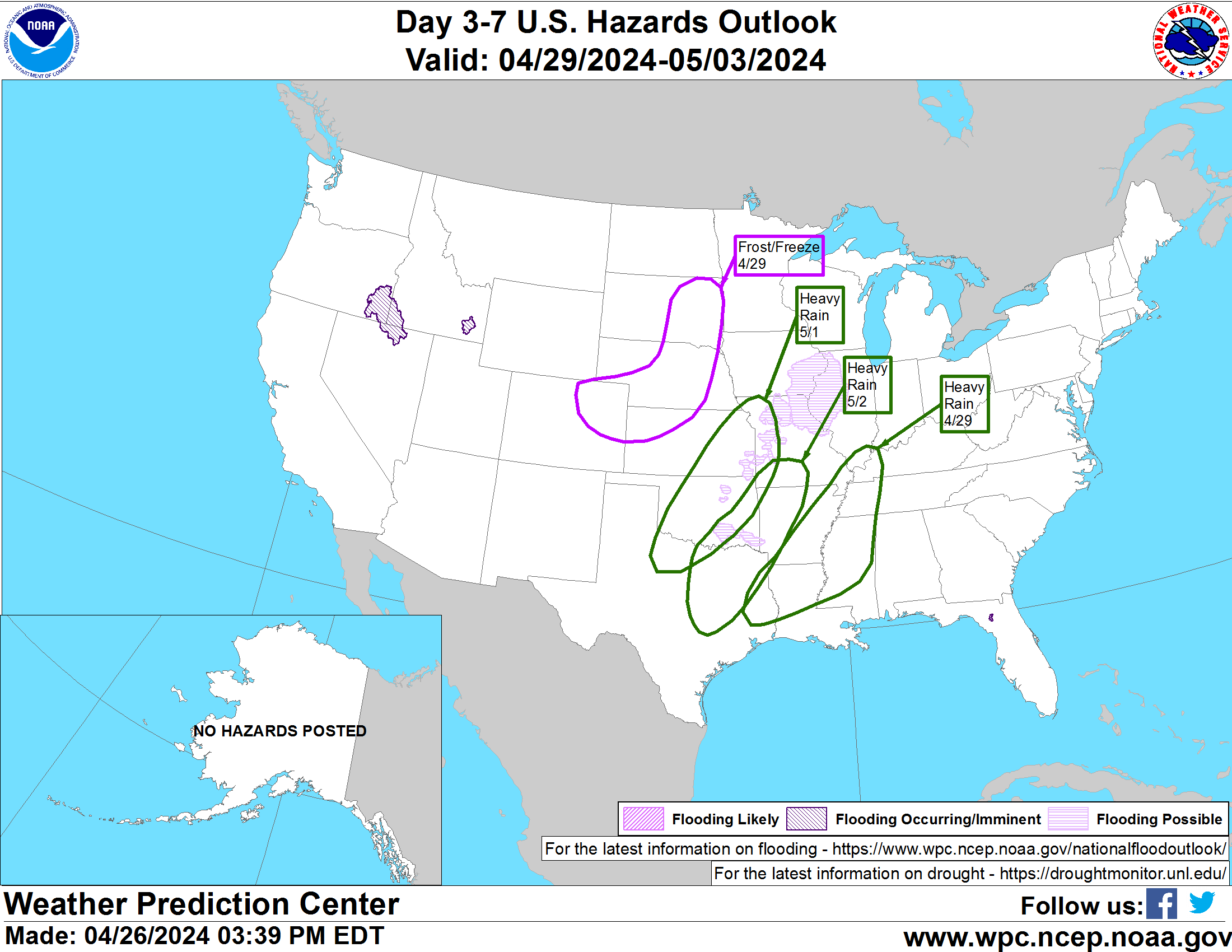
Day 3 - 7
Outlook!
Click map to
go off site for full size
and or Click here
to go to WPC's page!
|

There are several maps and links
below
|

Click the map to
enter their page


Click the
map to enter their page


Click
the map to enter their page

|
|
|