|
|
|
BeachNet
Remote Receiver Systems
Mountainous terrain, such as we enjoy here in the Discovery
Coast region,
can be challenging for siting repeaters. While the elevated
vantage afforded
by the peaks and ridges can be desirable for locating a
repeater, providing
generally good range, it is
not uncommon for our users
to experience multipath distortion.
This is caused by the user's
signal finding several reflected paths
to the repeater receiver,
none of which is truly
line-of-sight. These combine
to form a
phase-distorted signal.
If the distortion is severe enough,
the CTCSS (PL) tone can be
mutilated, not holding
the tone decoder, letting
the receiver squelch open and close
and the transmission
will "chop", making
it unreadable, even with a
relatively strong signal.
The hilly terrain
also causes users' signals
to become weak when they enter
shadowed "dead areas".
Even
when the user can hear the
repeater relatively well,
they find themselves unable
to continue a conversation.
The answer to this problem
is a remote
receiver placed close
to the user, so that it
hears the user better than
the repeater site receiver.
BeachNet
incorporates
two remote receiver systems.
The remote receiver system
supporting the
Megler
147.180 repeater,
is the more
elaborate,
consisting of
multiple remote
receivers, with individual UHF relay
links and a voting panel to
automatically
select the best of several
receiver feeds. This generally
overcomes the challenges
imposed by local terrain in
the south Pacific and
north Clatsop county areas.
The other remote
receiver system
is much simpler.
It supports the
North Cove,
145.310,
repeater coverage
along Highway 101,
from Naselle to Bay Center.
This system
consists of
a single remote
receiver in addition
to the repeater itself.
The user
determines which receiver is
used by selecting
the correct CTCSS (PL)
tone. This manual
selection method gives our
users complete control over
their signal routing into the
network.
Megler, 147.180
Repeater, Voting Receiver
System
Highway 101, and State
Routes 4 and 401 encircle
Megler Mountain on which
the Megler 147.180
repeater is
located. These highways
are "tucked under
the toe" of the hill,
meaning the bulk of the
mountain is blocking the
signal and there is
no direct path
to the repeater
from users on
these roads.
The signal path in places
is entirely reflected,
exacerbating
the multi-path
problem. While the user
can typically hear the
high-power signal from the
repeater fairly clearly
with minor flutter and
some noise, the relatively
weak signal from the
user back to the
repeater may be of
relatively poor quality.
To solve
this problem we have
installed several
Remote
Receivers for
the Megler
147.180 repeater.
These all listen on the
same channel
frequency, and use the
same CTCSS tone as the
repeater receiver. To
improve the
user experience,
an automatic Receiver
Voting System
manages
these resources
in real-time.
The Receiver Voting
System
uses a Voting
Panel at
the repeater site
to continuously evaluate
the signals fed in from
the receivers, and
"vote"
which of the five
has the best
signal-to-noise-ratio
at the moment.
The user does nothing
special to select the
best receiver, except possibly
to pause for a half-second
between keying-up and
talking. The
Voting System
selects the cleanest receiver feed
available
and presents that
to the repeater transmitter
automatically.
Of course, this signal is
also sent via the repeater
network linking system to
the other
BeachNet
repeaters.
The Remote Receivers
are deliberately located
around the perimeter of the
coverage area to provide a
clear line-of-sight path
from mobile stations
operating on the above-mentioned
highways. these sites also
have overlapping coverage,
virtually eliminating
dead spots
in the Megler
Repeater's coverage area.
Even in places
where the
repeater transmitter sounds
weak, with multi-path distortion
and rough copy,
the signal
from the user is clean and
clear. The signals from
all five receivers
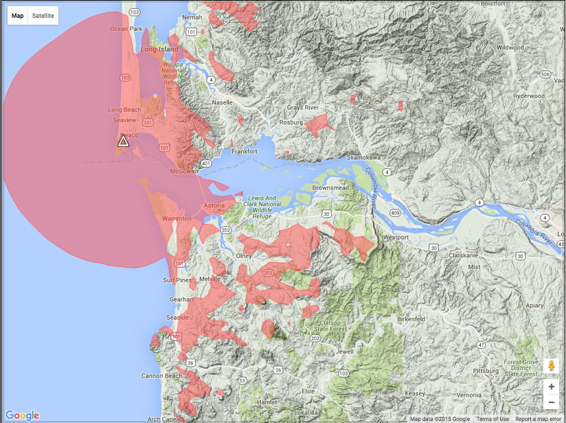
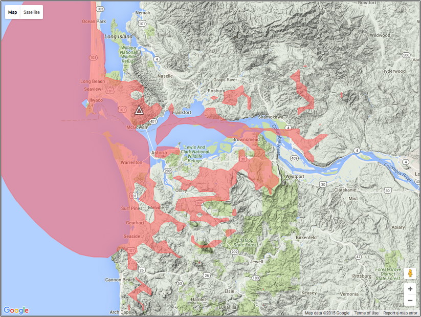
(Cape Disappointment,
Naselle, Warrenton,
Seaside and
the repeater receiver itself on
Megler Mountain), are
constantly evaluated and
the best of
the lot is routed to the
transmitter. If you
can hear the 147.180
Megler repeater clearly, you
can probably work it,
with a typical 50-watt
mobile and a 5/8-wave
vertical antenna.
The voting remote
receiver system was
brought
on-line between September
and November 2008, and
has been fully
operational since then.
To use the Remote
Receivers, set your
radio to 147.180 +600 kHz,
and your CTCSS (PL) tone to
82.5 Hz. The
voting system will
do the rest.
|

|
The Remote
Receivers:
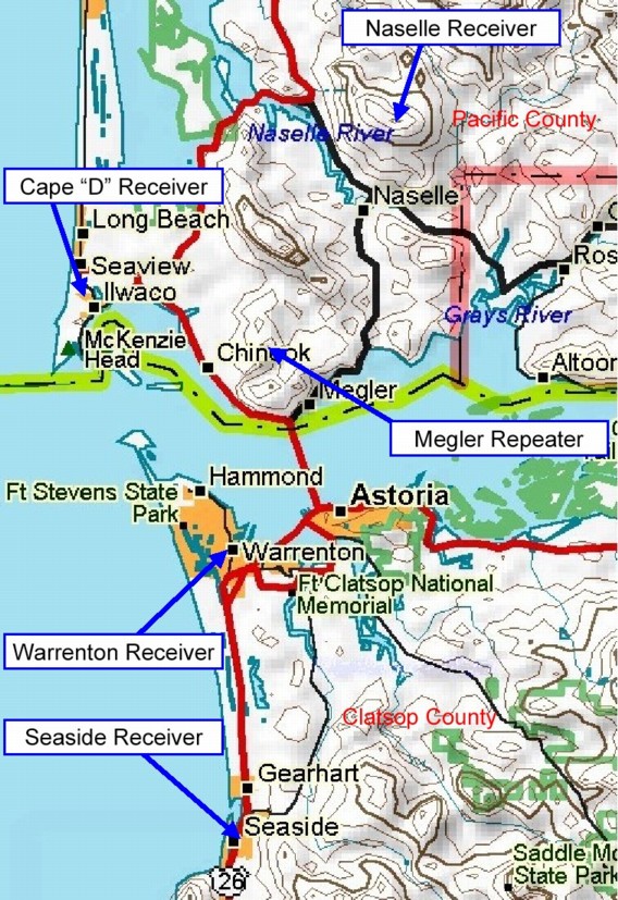
The
Naselle Receiver
(2000 ft),
covers
Hwy 4 from Wahkiakum
County (MP-44)
to "Johnson's
Landing"
(Hwy4 MP-0 at the Hwy101 junction);
Hwy401 from
the Columbia
River shore (Knapton), north to
Naselle; Hwy101 from
the Willapa
Wildlife Refuge
headquarters (Hwy101 MP-20)
north to Bay Center (Hwy101 MP-40);
and the northern portion
of the Long
Beach Peninsula.
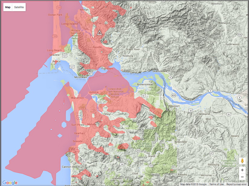
The
Cape D Receiver
(300 ft),
covers Cape Disappointment State
Park and environs; Hwy 101
from Astoria north to the
Willapa Wildlife Refuge
Headquarters; and the
southern two-thirds of
the Long Beach
Peninsula.
The
Megler
Repeater Receiver
(1300 ft),
covers the Peninsula
from Chinook north
to Oysterville,
and Astoria south to
Seaside and east to
Knappa.
The
Warrenton
Receiver
(30 ft),
covers Hwy 101
along the north shore of the Columbia
River from Chinook,
east to the
Astoria-Megler
Bridge, south
to Astoria; Hwy
401 from
the Bridge, east to
Knapton; the
south side of
the hill in
Astoria; and Hwy 101 south
toward Seaside.
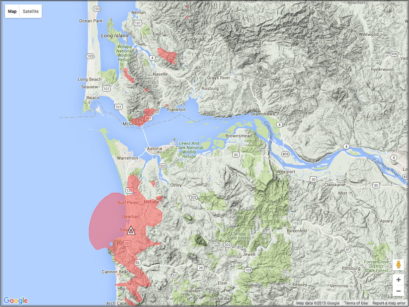
The
Seaside
Receiver
(100 ft),
covers the city of Seaside,
its environs, and Hwy 101
from the Hwy 26
junction, north toward Warrenton.
This receiver
offers hand-held coverage for the
SeaPac Ham Convention and the
Hood-To-Coast Relay.
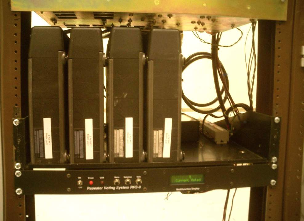
Four UHF link receivers and Voting Unit at the Megler site
|
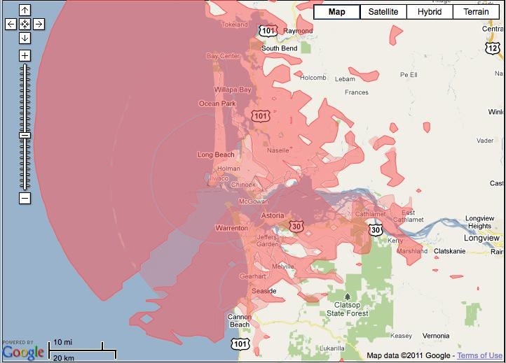
Click Here or on Map to View Megler Repeater Receiver Locations
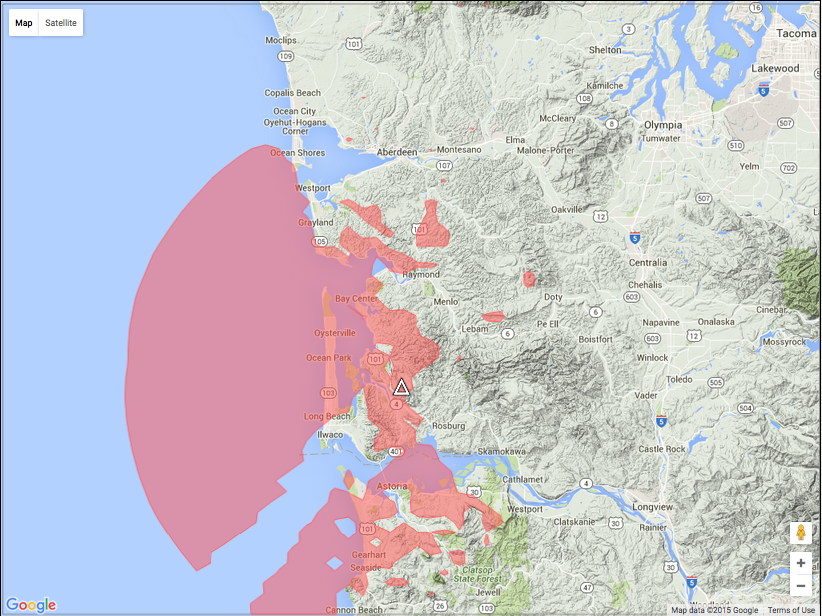
Click here for a plot of Combined Megler Receiver Coverage
Click here for Main System Coverage Map
North
Cove, 145.310 Repeater, Remote
Receiver
One particularly
"rough" area
for our
North Cove
repeater coverage
is along Highway 101 from Milepost-26
(north of the Naselle River Bridge,
but south of the the Hwy 4 Junction near Naselle)
to Milepost-42
(the Palix River Bridge near Bay Center)
The
North Cove repeater
transmitter serves
this area fairly well,
but with a site elevation
of only 400 feet,
the
signal received by
the repeater can be
marginal from this
deeply forested area,
due to
multi-path
distortion
and local
terrain obstacles.
To solve this coverage
problem, a
Remote
Receiver
is
located at 2000-feet on
Naselle Ridge to pick up
users' signals from an advantageous
location.
This high-level site
provides superior
coverage
to most of the
area served
by the North
Cove repeater.
Installing a 2-meter
repeater
here would be
problematic, due
to the scarcity of
available frequency
pairs, and the strong
likelihood of causing
interference to an
existing out-of-area
repeater in that band.
The installation of
a Secondary
Receiver,
however is not
so difficult,
as our receiver
is unlikely to
interfere with
another repeater
elsewhere.
To utilize
this Naselle Remote
Receiver
to improve your signal,
all that is necessary
is to change your PL
(CTCSS) tone to
114.8 Hz.,
from the standard
118.8 Hz. used for the
repeater site receiver.
Many users install a
second memory channel
in their radio which
transmits the
different PL tone.
In fact, there are few
areas where this secondary
receiver doesn't provide
better performance than
the primary receiver at
the repeater site.
|
|
North Cove Receiver
Naselle Receiver
|
To use the North
Cove Repeater with
or without the Remote
Receiver, set your
radio to 145.310,
-600 kHz,
and your PL tone to:
118.8 Hz.
to
select the
North
Cove Receiver
(400
ft. Elevation),
located on the
ocean bluffs above
Tokeland.
114.8 Hz.
to
select the
Naselle
Receiver
(2000
ft. Elevation),
located on Naselle
Ridge above Naselle.
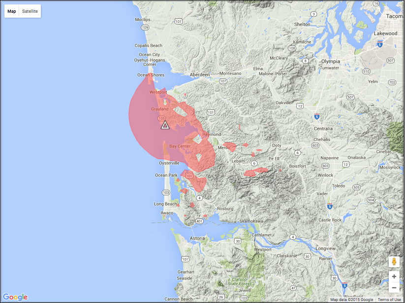
The
North
Cove Repeater
covers an area including
Highway 101 from the Hwy 4
Junction, "Johnson's
Landing", north to
South Bend, and
then west
on Hwy 105
to Tokeland
and Grayland. Within
most of
this area, the
Naselle
Receiver
helps greatly,
providing a superior
receiver, assuring
your signals will
be picked up
clearly.
|
|
Click Here or
on Map to View North Cove
Repeater Receiver Options
Click
here for Main System Coverage
Map
|
For problems or questions
regarding this website contact
Webmaster.
Copyright
BeachNet
Website
2002-2016.
All rights reserved.
This Page Last Updated: 07/26/18.
|
|
