|
|
|
|
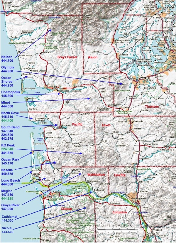
BeachNet System Network Linking Capabilities
Neilton 444.700: (4 links)
KO Peak, South Bend, Minot, Olympia
Olympia (CPU) 444.950: (4 links)
KO Peak, South Bend, Minot, Naselle
Ocean Shores 444.200: (8 links)
KO Peak, South Bend, Minot, Neilton, Naselle, Olympia,
Megler, Aberdeen
Cosmopolis (Cosi) 145.390: (8 links)
KO Peak, South Bend, Minot, Neilton, Naselle, Olympia,
Ocean Shores, Aberdeen
Minot 444.050: (2 links)
KO Peak, South Bend
North Cove 145.310: (8 links)
KO Peak, South Bend, Naselle, North Cove UHF, Megler UHF
North Cove 444.400: (10 links)
KO Peak, South Bend, Naselle, Nicolai,
Long Beach, Megler UHF, more
South Bend 147.340 & 442.675: (2 links)
KO Peak, Naselle; (1 link for either, neither or both repeaters)
South Bend 224.820: (15 links)
KO Peak, Naselle, South Bend, Minot, North Cove, Nicolai,
Neilton, Long Beach, Olympia, Megler
6-Meters: (8 links) Nicolai, North Mt., BawFaw, Tiger Mt., Capitol Peak, Grass Mt., Simplex.
Ocean Park 145.170: (16 links)
KO Peak , Naselle, South Bend, Minot, North Cove, Nicolai, Long Beach, South Bend,
Megler, Neilton, Olympia, more
Megler 147.180: (8 links)
KO Peak , Naselle, South Bend, North Cove, Megler, more
Grays River 147.020: (16 links)
KO Peak, Naselle, South Bend, Nicolai, Megler, Cathlamet,
more
Cathlamet 444.300: (16 links)
KO Peak, Naselle, South Bend, Nicolai, Megler,
more
Nicolai 444.500: (4 links)
KO Peak, Naselle, South Bend, more
KO Peak 441.675, Naselle 440.675 & Long Beach 444.800:
Have frequency-agile remote base stations covering any frequency
in the 144-148, 223-225, 440-450 bands (KO also has 10m & 6m), including standard repeater offsets and CTCSS tones.
|
|