
VK6RBS Transmitter |
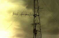
Antenna tower |
Note: Busselton VK6RBS is currently
not operational.
Please Read - The Future: -
at foot of this page.
VK6RBS Busselton began operation from a site at the Geographe Bay Yacht Club in 1984.
|
development of the coastal duct which frequently forms along the Western Australian coast north to Exmouth, about 1500 Km distant. It was also arranged that there would be radiation generally to the
East
The site is unusual in that the antennas are located on a 10 metre
tower which
|
|
output of 40 watts, with associated FSK morse ident and power supply. This is housed in the Yacht Club storage loft adjacent to the tower. The 40 watts on 144.022 Mhz is fed up the tower to a 3dB power divider,
The 432 Mhz antenna is a centre fed, three halfwavelength dipole
with a
The 1296 Mhz antenna is a corner reflector directed to the north. The northerly bearing from Busselton is approximately
|
|
between Busselton and Perth. The 144 and 432 Mhz transmissions are always audible over the 200 Km path, with the signal varying between scatter levels to free space. The 1296 Mhz signal is not always audible, but when enhancement occurs the signal level is comparable with the other outlets. The transmissions have been received over a wide area along the coast to the north and inland, but reports of extension to the east have not eventuated. The latter could be attributed to the sea level location. The beacon outlets have also provided useful propagation indicators
to the
|
|
VK6RBS Transmitter |
Antenna tower |
|
the multiplying system is the inflexibility of the frequencies resulting. The present operating frequencies do not and cannot conform to the recommended Band Plan. In addition, the use of FSK with the multiplying system results in increasing shift in proportion to the multiplication used. The WA VHF Group therefore propose
Initial plans are to close the 144 Mhz frequency,
which would be
|