AMATEUR RADIO LIGHTHOUSE SOCIETY

2004 - Date TBA
CHRISTMAS LITES
QSO PARTY
Lighthouse Activiation - by W1EMT (ARLHS #421)
BEAR ISLAND LIGHT - USA - 045
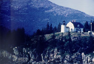
Photo courtesy of Acadia National Park, 1993
LIGHTHOUSE DATA:
State: MAINE
Location: BEAR ISLAND/ENTRANCE TO NORTHEAST HARBOR
Nearest City: NORTHEAST HARBOR, MT. DESERT ISLAND -
(IOTA NA-055)
County: HANCOCK
U.S.C.G. District: 1
Year Station Established: 1839
Existing Historic Tower:
- Year Light First Lit: 1889
- Is the Light Operational? YES (PRIVATE AID TO NAVIGATION)
- Date Deactivated: 1981-1989
- Automated:
- Foundation Materials: GRANITE RUBBLE
- Construction Materials: BRICK
- Markings/Patterns: EXPOSED BRICK TOWER W/BLACK LANTERN
- Shape: CYLINDRICAL ATTACHED TO WORKROOM
- Relationship to Other Structures: SEPARATE
- Tower Height: 31
- Original Optic: FIFTH ORDER, FRESNEL
- Year Original Lens Installed: 1858
- Present Optic: REMOVED
- Year Present Lens Installed:
- Height of Focal Plane: 100
- Fresnel Lens Disposition:
- Has tower been moved? NO
Previous Tower(s):
1. Construction Date:
Description:
Fate/Disposition:
Modern Tower? NO
Existing Sound Signal Building? NO
- Fog Signal Type: BELL
Existing Keepers Quarters? YES
- Year Constructed: 1889
- Number of Stories: 1.5
- Architectural Style: GAMBREL ROOF
- Construction Materials: WOOD
Other Structures: STONE OIL HOUSE (1905), BOATHOUSE, BARN (1889)
Current Use: PRIVATE AID TO NAVIGATION
Owner/Manager: NATIONAL PARK SERVICE LEASE TO PRIVATE OWNER
Open to the Public? NO
National Register Status: LISTED Reference #88000043
Name of Listing: BEAR ISLAND LIGHT STATION
On State List/Inventory? NO
Miscellaneous:
REPLACED BY AN OFFSHORE BUOY IN 1981; FRIENDS OF ACADIA NP WERE GIVEN
PRIVATE AID TO NAVIGATION PERMIT IN 1989
AMATEUR RADIO OPERATIONS:
Operator: Jim Wilmerding
Station Call: W1EMT/qrp
Station Location: Shore of Northeast Harbor, Maine - Mt. Desert Island
TIMES: TBA (other times during day or by schedule request - e-mail [email protected] )
Frequencies: Alternating - 14.270, 21.370, 28.370 & 18.157.5 (HF Pack)
NOTE: Additional operating times will be scheduled during the week - Posted here and ARLHS BeaconBot
Station Equipment: SGC SG-2020 - half square wire & end-fed long wire antennas & Buddiepole - Z-11 Antenna Tuner - 26 amp hr SLA battery - power out 5 -10 watts
Activation: Visual Line of Site/1,000 meter rule utilized
QSL: via QRZ.com address - Business size SASE please - "Greenstamps" appreciated (photo postcards $$)
 |
[
Join|
Skip Previous|
Previous|
Next]
This RingSurf
"Amateur Radio Lighthouse Ring" site |
|