CAMPBELL ISLAND HISTORY
Campbell Island was discovered in January 1810 by Captain Frederick Hasselburg of the sealing brig, Perseverance. Hasselburg named the island after his employers Robert Campbell and Co. of Sydney. On a later visit that year Captain Hasselburg, along with a woman called Elizabeth Farr and a young boy called George Allwright, were drowned when their jollyboat capsized in Perseverance Harbour. Jas Bloodworth pulled the body of Elizabeth Farr ashore, and she was probably buried in a cove at the head of the harbour.
When a new sealing ground was discovered the find was usually kept secret, for once its whereabouts became known the uncontrolled slaughter that followed quickly reduced seal numbers to an unprofitable level. Therefore, little is known of sealing visits to Campbell Island. Around this time sealing activity was declining in the subantarctic, but the taking of skins continued
spasmodically until about 1830. Efforts by the New Zealand government to conserve seals by patrolling closed seasons failed because of the remoteness of the islands and the resourcefulness of the poachers.
After the initial sealing period there followed a period of exploration into the region south of the 60th parallel. In 1838 Balleny in the Eliza Scott and Freeman in the Sabrina set out to explore the eastern sector of this region. They used the subantarctic islands as `stepping stones' taking sealskins and oil to offset expenses and water and wood to prolong the voyage. They visited Campbell Island from January 10-17, 1839. On the first day Freeman found four people who had been left on the island 4 years earlier by a sealing ship. The extent to which the seal population had diminished is shown by the fact that this party had collected only 170 skins.
In the nineteenth century some exploratory expeditions were sponsored by governments, frequently as a result of petitions of scientific and learned societies. The members of two such expeditions spent some time on Campbell Island.
The first of these was the British James Clark Ross expedition of 1840-42. The objective of this expedition was to identify whether or not the islands were once part of a main continent or whether they had been created by isolated uplift and volcanic events. Two scientists accompanying Ross, J Hooker and D Lyall, compiled the first plant and animal inventories for Campbell Island.
The second was sponsored by the government of France to observe the transit of Venus. In 1873 a preparatory expedition under Captain J Jacquemart (on board the frigate Vire) spent almost a month at the island. The ship returned with the main party (lead by A Bouquet de la Gyre) in 1874 and remained for three months. Although Venus was only glimpsed momentarily, just as it began to cross the sun, the other scientific findings of the party made the expedition a success. One member of this expedition, M Duris, died of typhoid fever on the island and was buried on the point opposite Venus Cove. An inscribed tombstone and iron cross were erected over the grave which has not been found.
From 1868 to 1923, both British Navy and New Zealand government vessels made periodic visits to the island to service a castaway depot (at Depot Point, Perseverance Harbour), one of the several erected on subantarctic islands.
Sheep, goats and pigs had been liberated at various times prior to 1895 with the intention of providing sustenance to the shipwrecked, but none of these animals survived for very long. Fires had been started occasionally by accident or by design and rats had been reported as well established on the main island by 1874. However, it was after 1895 that the large-scale modification of the vegetation was precipitated by the establishment of a farm on the island. Sheep were re-introduced in 1895 after the island (Pastoral Run No. 511) had been leased to J Gordon for a term of 21 years. In 1907, 10 scientists from the Philosophical Institute of Canterbury Subantarctic Islands Expedition spent 8 days on the island. They were the first scientific group to record the effect of sheep grazing on the vegetation.
Since the islands' discovery in 1810 whalers were well aware of Campbell's close proximity to routes used by whales making their annual winter migration to the north. The last of the shore whaling stations was located at North West Bay and operated from 1909 to 1916, in conjunction with management of the sheep run. The whalers' tow boat was lost in 1913 after which few whales were caught.
The farming era lasted until 1931. The original and renewed leases had changed hands a number of times and an unreliable transport system, accidents and a world-wide recession finally made farming uneconomic. The farmers withdrew and left about 4000 sheep and between 20 to 30 cattle unattended on the island. In 1937 the second lease expired and was not renewed.
A wartime coast-watching station was established
in 1941, 400 metres inland from Tucker Cove. When the coast-watching station was abandoned at the end of the war, radio meteorological activities continued at Tucker Cove. The station now occupies a new base at Beeman Cove, opened in November 1958. This base was decommissioned in late 1994. The old base is derelict.
In the post-war years three scientific expeditions were made to the islands by physicists and biologists including a visit by the Danish research vessel Galathea in 1951.
In 1954 the islands were declared a reserve for the preservation of flora and fauna under the continuing control of the Department of Conservation.
For some years after the abandonment of the farm,
various people concerned about the island's indigenous plants and animals, had called for
the eradication of the sheep.
VEGETATION OF CAMPBELL ISLAND
The vegetation is predominantly tussock grassland, shrubland and herbfield. Dracophyllum species, Coprosma species and Myrsine approach tree size (5 metres) in sheltered places. Limited tree growth results from high winds combined with cool temperatures. One introduced specimen of Picea (spruce) grows on the island and is about 6 metres tall.
For ecological description Meurk (1977) divides the
vegetation into three super-oceanic altitudinal zones: the upper alpine, lower alpine and
subalpine. Within these zones he also recognises several intra zonal communities and some
induced states. The most extensive associations are described below.
The tall rush/herbfield association predominates in the high alpine mosaic of vegetation. It is dominated by the rushes Marsippospermum gracile and Bulbinella rossii (seasonally) but a wide range of grasses, forbs, lichens and bryophytes form a dense underturf. The bronzy green of most parts of the island above 300 metres is due to the dominant plants of this association. Before the advent of grazing animals Pleurophyllum speciosum, Anisotome antipoda and dwarfed Stilbocarpa polaris would have been more common components of this association.
Other associations within this zone include that of:
1. the fellfield and bluffs dominated by lichens and mosses with vascular plants on sheltered ledges;
Other associations include rock and ledge vegetation; Chionochloa/cushion bog `lanes' (linear strips) as well as raised cushion-bogs which develop on the drainage patterns, Coprosma/Myrsine shrub flush, tall sedge swamp. tarn and riparian associations, pioneer mixed herbfield on peat slips and associations formed naturally in conjunction with bird and seal colonies.
This zone is characterised by a dwarf forest of
Dracophyllum scoparium and D.longifolium, with Coprosma species and Myrsine, which in places attains a height of 5 metres.The tall ferns,
Polystichum vestitum and Histiopteris incisa provide a lower middle stratum (about 1 metre high) in glades and bush margins. The ground layer comprises herbs such as Epilobium pedunculare, Stellaria decipiens and Uncinia species and the mosses Ptychomnion densifolium and Acrocladium auriculatum. Epiphytic lichens (Pseudocyphellaria species, Sphaerophorus species and Psoroma species), mosses (eg Macromitrium longirostre), liverworts and ferns (Grammitis magellanica and Hymenophyllum minimum) are also present. The abundance of Myrsine and Coprosma seedlings aloong with the lack of Dracophyllum juveniles suggest that a true steady state has not yet been reached.Other associations recognised within this zone are:
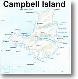
The Island is the dissected remnant of a volcanic dome. Marine erosion has removed most of the western half of the volcano, while on the east the `drowning' of radial valleys has created a series of fiord-like inlets separated by gently sloping ridges. The coast is mainly cliffs and outlying stacks, rocks and islets abound.
The basement rocks are composed partly of schist, probably of lower Palaeozoic age (dating from 640 million years ago). This crops out at the base of the cliff west of Northwest Bay and on the lower foreshore at the head of Perseverance Harbour. Overlying the schist unconformably is a Cretaceous sequence of sandstone, conglomerate, and carbonaceous mudstone. In turn, these are followed by the Tertiary period Tucker Cove Limestone which is about 170 metres thick and exposed near sea level (where it has been domed upward by movement at the central part of the volcano). The Shoal Point Formation is a marine fossiliferous deposit of re-worked volcanic sediment. It is comprised of yellow-green tufts and dark coarse grained breccia, overlies the Tucker Cove Limestone and crops out extensively in western and central areas. Grey gabbro, Menhir gabbro of Miocene age, extends north to Northwest Bay.
Nearly two-thirds of the island is covered by volcanic flows which always overlie the Shoal Point Formation. The flows were erupted from a centre, north of Northwest Bay, now removed by marine erosion. Individual flows usually dip at 1 to 4 degrees, and vary from 1 to 50 mm in thickness. Together they have a total thickness probably in excess of 300 metres (Adams et al. 1979). Beeman Hill appears to be the neck of a subsidiary cone.
The island was subjected to the action of ice during the Pleistocene era (dating from 2 million years ago) but there are differing opinions on the origins of the glacial landforms. Fleming (1977), on the evidence of the glacial troughs and cirques, suggests that permanent snow and ice accumulated above about 160 metres. Beggs (1980) notes that the topography is not as steep as in classical glacial terrain and that there is no obvious source area for large valley glaciers. He suggests that periglacial processes may have been the principal land sculptors. Moraine, fluvoglacial sediment, and raised beach deposits are found covering limited areas of the island.
There is a pronounced topographic influence on soil development. Deep peat occupies flat and gently sloping areas, but on steeper surfaces the mineral content of the soil increases and the peat mantle is generally less than 2 metres thick. The mass movement of peat, especially over impervious bedding planes in the sedimentary rocks, is widespread and conspicuous. Other forms of erosion include deep-seated slumps, and in isolated areas tunnel gully erosion and scree erosion. Wind erosion have occured, however, is the most extensive as revealed by blowout scars especially on exposed ridges and spurs at higher altitudes. Such scars appear to be healing on the northern side of the stock fence but are still being damaged by stock trampling in the south. Damage associated with tracking is also very evident. The soft, weakly consolidated peat is easily destroyed and this exposes the drier surface layer of soil to erosion by wind and water. Soil disturbance is also noticeable along the fence line.
BIRDS OF CAMPBELL ISLANDCampbell Island is the best known of all New Zealand's Sub Antarctic islands. It was permanently manned from 1941 - 1995. Consequently stragglers and migrants are more likely to be recorded.
SPECIES(in checklist order)
King penguin
Yellow eyed penguin
Gentoo penguin
Rockhopper
Macaroni penguin
Erect crested penguin
Wandering albatross
Southern royal albatross
Black browed mollymawk
Grey headed mollymawk
Light mantled sooty albatross
Giant petrel
Cape pigeon
Sooty shearwater
Grey petrel
White chinned petrel
White headed petrel
Grey backed storm petrel
Black bellied storm petrel
Subantarctic diving petrel
Black shag
Little shag
Campbell Island shag
White heron
White faced heron
Campbell Island teal
Grey duck
Mallard duck
Australian harrier
New Zealand falcon
Pukeko
South Island pied oystercatcher
Spur winged plover
Banded dotterel
Eastern bar tailed godwit
Hudsonian godwit
Knot
Turnstone
Southern skua
Antarctic skua
Southern black backed gull
Red bill gull
Antarctic tern
Arctic tern
White fronted tern
Skylark
Welcome swallow
Song thrush
Blackbird
Hedge sparrow
New Zealand pipit
Silvereye
Greenfinch
Goldfinch
Redpoll
House sparrow
Chaffinch
Yellow hammer
Starling
This page designed and maintained by N1DG.
Last updated 10 October 1998