KO Peak
Pacific County, WA
46.461068, -123.550658
2900 Feet
Call: N7XAC
224.040 -1.6MHz 118.8Hz

KO Peak 1.25m Repeater
|
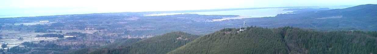
Location: KO Peak is the highest radio site in Pacific County, and
is located 6 miles south of Lebam, WA. It is 12 miles by logging road
from the highway, and can be inaccessible much of the year due to
lingering snow because the road climbs the northern face of the mountain
and much of the road is in shadow nearly all the time.
Coverage: KO Peak is a great
long-range site, and both repeaters
can be worked directly from Tacoma, Olympia
and northern Grays Harbor County
on the north; Vancouver, WA, and Seaside, OR
on the south and well out to sea
to the west. The coverage within Pacific
County can be spotty, with
some very good locations and some not so
good. The "KO" repeaters are
very strong in the Willapa
Valley, and northern Pacific County, as
well as portions of Grays Harbor
County, along the Interstate-5 corridor,
and on the Long Beach Peninsula.
Click here for a
detailed site plot for the UHF machine,
but representative of the coverage from
both repeaters, with the 224.040
being moderately better.
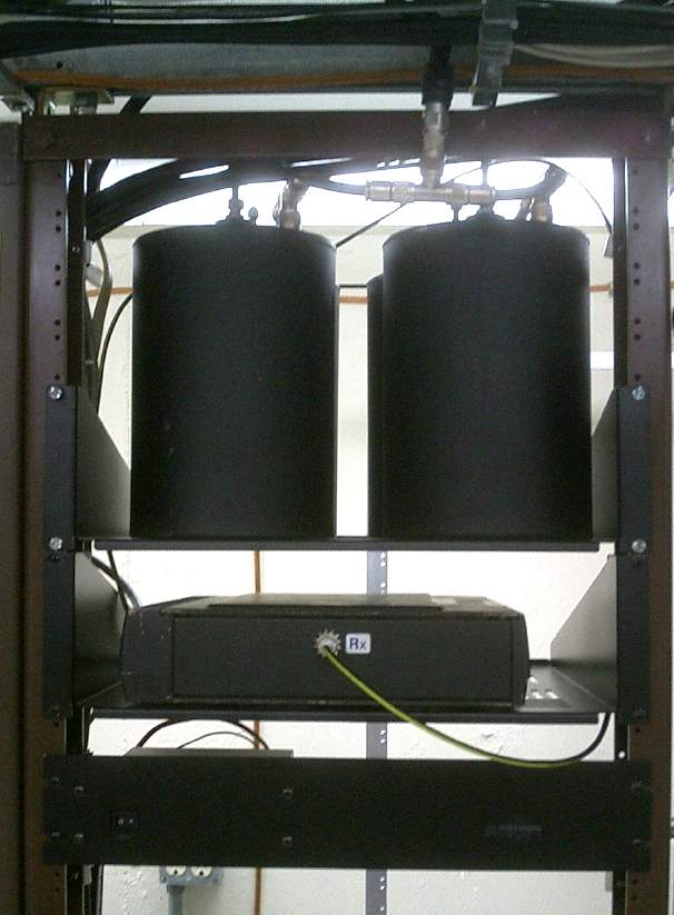
Hardware: The 224.040
repeater is a converted Motorola mobile, with an
internal controller and a switching power supply feeding a
(new May 2010) Stationmaster gain vertical at the top of
the tower through 7/8-inch hardline.
The duplexer is a low-loss unit with
large-bore cavities. Of course, attention has been
paid to proper lightning protection.
The KO Peak site is instrumental in conjunction with the
BeachNet
linking system to knit the network together. The UHF and VHF repeaters
each have their role, and both can be accessed directly from the
Washington State Emergency Coordination Center at Camp Murray. This is a
keystone of the Pacific County ARES/RACES Emergency Plan.
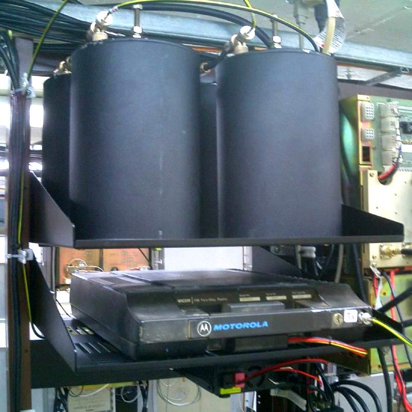
Click here for information on the UHF
441.675 MHz repeater.
The KO Peak 224.040
repeater normally
operates independently, as a stand-alone
resource. When desired, it can be linked
into the network using the remote bases.
From an Emergency Communications
standpoint, it is routinely used as a
conduit for connecting the Emergency
Operations Centers (EOCs) of the Southwestern
Washington counties to
the Washington State ECC at Camp Murray
in times of disaster. The
prudent emergency planner never relies
on any single resource without
considering alternatives, in case
of failure. However, this repeater
has a lot to recommend it as one
tool in the EmCom toolkit.
One-and-one-quarter-meters has a
unique spectral location, being relatively distant
from any commonly-used commercial or public safety
radio frequency. Both the more popular 2-meter and
70-centimeter bands are adjacent to such other
radio users, and this can cause
some interference potential
in the close confines involved in EmCom support
of official agencies.
The use of 224.040 for EmCom also frees
both of the more popular 2-meter and 70-centimeter
bands for more intensive local use without interference.
And, finally, one must also look at the fact that, since
most scanners don't cover the 222 MHz band,
its use reduces the number of ears listening.
Outside of emergency support work, the 222 MHz.
band has much to recommend it. The propagation is at least
as good as 2-meters, and there is a lot less
noise (radio "smog") at most sites.
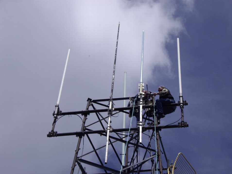
History:
The KO Peak station took
a direct lightning strike
on November 7, 2009,
vaporizing the
UHF antenna,
damaging the
nearby 220-MHz antenna.
The lightning strike caused
the UHF antenna to literally
explode as the conductor
inside the fiberglass shell
turned instantly from metal
wire to super-heated ionized plasma,
trying to carry
the thousands of Amperes of
current delivered. The
fiberglass shrapnel
sliced open the phasing harness
on the 220-MHz antenna and
sandblasted the radiator elements.
The 220 antenna
was replaced in May, 2010.
|
