|
|
|

|
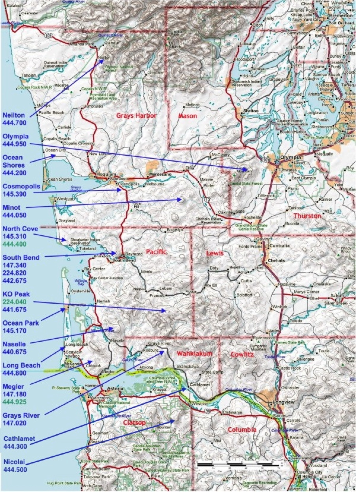
Repeater Recommendations for major Highways
Northwest Grays Harbor County, Hwy 101 north of Hoquiam:
Neilton 444.700, Cosmopolis 145.390, Ocean Shores 444.200
Ocean Shores east to Hoquiam/Aberdeen and Elma, Hwys 12, 107:
Cosmopolis 145.390, Ocean Shores 444.200, Minot 444.050
Tacoma & Hoodsport south to Longview on I-5 and Hwy 101:
Olympia 444.950, KO Peak 441.675, Minot 444.050
Elma to Centralia, Hwy 12:
Olympia 444.950, Minot 444.050
Aberdeen, west to Westport, Hwy 105:
Cosmopolis 145.390, Ocean Shores 444.200
Westport south to Tokeland, east to Raymond, Hwy 105:
North Cove 145.310, Naselle 440.675, South Bend 147.340
Aberdeen, south to the Grays Harbor/Pacific County Line, Hwy 101:
Cosmopolis 145.390, South Bend 147.340, KO Peak 441.675
Pacific/Grays Harbor County Line south to Raymond, Hwy 101:
South Bend 147.340, Cosmopolis 145.390, South Bend 442.675
Raymond east to Chehalis, Hwy SR6:
South Bend 147.340, KO Peak 441.675, Minot 444.050
Raymond south to Bay Center, Hwy 101:
South Bend 147.340, North Cove 145.310, South Bend 442.675
Bay Center south to the 101/SR4 Junction, Hwy 101:
North Cove 145.310, Ocean Park 145.170, Long Beach 444.800
Naselle east to Longview, Hwy SR4:
Grays River 147.020, Cathlamet 444.300, Nicolai 444.500
From the 101/SR4 Junction south to Astoria, Oregon, Hwy 101:
Megler 147.180, North Cove 145.310, Long Beach 444.800
Naselle south to Astoria, Oregon, SR 401:
Megler 147.180, Grays River 147.020, Naselle 440.675
Long Beach Peninsula:
Megler 147.180, Long Beach 444.800, North Cove 145.310
Astoria, Oregon east to Longview, Hwy 30 (OR) or Hwy 4 (WA):
Megler 147.180, Grays River 147.020, Nicolai 444.500
Longview/Kelso to Woodland I-5:
Nicolai 444.500, Grays River 147.020, KO Peak 441.675
|