
Introduction To Grimspound
Dartmoor is a region of high moorland overlying a large area of granite which is situated in the county of Devon, South West England and covers an area of over 360 square miles. It was declared a national park in 1951 and is now overseen by the Dartmoor National Park Authority.
Evidence of early human occupation can be found on the moor and it has been estimated that there are around 5,000 hut circles scattered over the area. Also to be found are the ancient remains of entire villages or settlements, the best-known one being Grimspound.

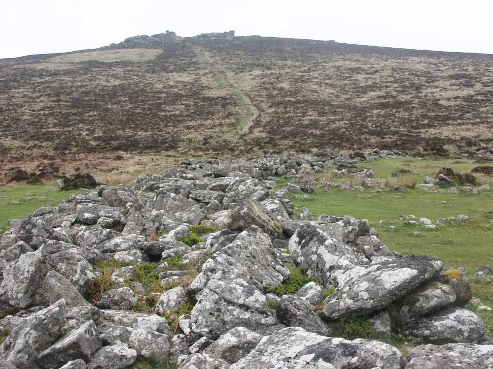
Grimspound as seen from the adjacent Hookney Tor, the main entrance visible at the rear
The site itself consists essentially of a walled enclosure or pound of just over four acres in area and measuring at the widest points roughly 133 metres by 155 metres. Within the wall are the remains of many structures, most taking the form of circles of granite boulders, the remains of small stone-walled huts.

Photo 1
Evidence of tin streaming
Although Grimspound is located at around 450 metres above sea level, it wasn't well-placed from a defensive view as it was overlooked by the adjacent high points of Hookney Tor and Hameldown Tor. I believe it was not built as a fortification as was believed by some but rather the home of a farming community. The inhabitants normally credited with its construction may simply have moved into an existing site, and for certain some of the huts have been used in more recent times as temporary shelter by various people including the early tin streamers who worked the area for surface deposits of tin ore.
Evidence of historic tin extraction can be seen on the side of the opposite valley, where tin streaming operations have left a number of deep gullies cut into the side of the hill, shown in photo 1. Although this particular operation is much more recent than Grimspound, it does demonstrate the occurrence of tin in the area, which may be of significance.
Grimspound is often described as having been built in the Bronze age about 3,000 years ago, but the complete absence of any metal artefacts, smelting residue or pottery suggests the site is more likely to be of Neolithic origin, evidence for this being in the form of some excavated flint fragments.
The Devonshire Association 1894 (Vol.26), page 118
It is therefore a legitimate conclusion that the population who occupied Grimspound, or used it as their place of refuge, belonged to a very primitive age; that they were clad in the skins which they cleaned with the flint scrapers; that they were ignorant of metal, and that they were a pastoral race, having flocks of sheep, and probably also cattle: that is to say, they belonged to the Neolithic age, and possibly to a very early period in that age.
- Baring-Gould, Burnard, et al (1894)
A number of theories had in the past been thrust forward to try to explain what Grimspound was built for, some less likely than others. One idea was that it was "the seat of judicature for the cantred of Darius" (Polwhele), others believed it to be simply a fortress, others even believing Grimspound to be associated with the work of the devil. In 1893 the Dartmoor Exploration Committee was formed to investigate various ancient remains on Dartmoor including Grimspound, to try to establish some facts about the structures and to attach a date to them, if possible.
Visiting The Site
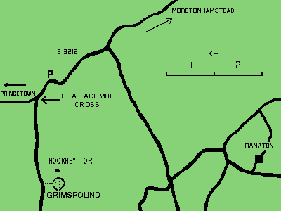
Fig. 1
A map of the vicinity
A glance at the map in fig. 1 will give you some idea of where to find Grimspound once you are in the vicinity, as there are no directions to it posted on the roads. The site is under the care of English Heritage and as it is on open moorland, it is free of charge to access.
Directions:
Follow the B3212 for about 4 miles from Postbridge in the direction of Moretonhampstead until you find Challacombe Cross, a small junction to the right sign-posted to Widecombe-In-The-Moor. Grid reference of this junction is SX 69470 83060, What3Words lottery.bike.staining.
After turning right here, travel for around 1·4 miles down this narrow road until you see a tarmac pull-in on the right, room for perhaps 5 cars. Grimspound is a few hundred yards up the steep bank on the left, the path being very clear and easy to follow as it is well worn and the more susceptible parts have been paved with granite slabs to protect these areas from erosion due to walkers. Although easy enough for able bodied people to negotiate, it is not suitable for wheelchairs or the severely disabled due to the nature of the terrain.
Over the years several official archaeological surveys of the site have taken place with varying degrees of accuracy, the earliest I am aware of being the 1829 survey by A.C. Shillibear, and I consider the map thus produced to be of particular importance as it shows the site as it was before the disruption caused during a major excavation which was initiated by the Dartmoor Exploration Committee in 1894, the report of which was published in Report & Transactions of the Devonshire Association.
The map of the site shown in fig. 2 is my own record of the features to be found at Grimspound after close examination of the enclosure. Although the final graphics are my own work, this map was based heavily on the Shillibear map. It is reproduced here simply as an aid for any visitors who wish to identify the various structures within the enclosure, and the numbers I have used for the huts follow the convention set during the 1894 to 1896 excavation to avoid ambiguity.

Fig. 2
Map of the features at Grimspound
The dotted line running horizontally through the map represents the old Manaton to Headland Warren path, the actual construction date of which I am unsure although it must have been before the turn of the 19th century. The builders saw fit to build straight through the site rather than around it, creating as they did two new breaks in the perimeter wall and damaging evidence of parts of the enclosures to be found at the western side.
Note that a small stream flows through the lower end of the site, which may have provided a useful source of water. However, it is worth considering that Dartmoor was once a heavily wooded area with a somewhat milder climate than it experiences now, and it is currently the deep layers of accumulated peat (a feature of moorland rather than a woodland environment) soaking up the rainfall which is probably responsible for the stream seen today; it is entirely possible that no stream at all existed here at the time of Grimspound's earliest occupation, although water would have been available from the stream at the bottom of the valley.
The Perimeter Wall

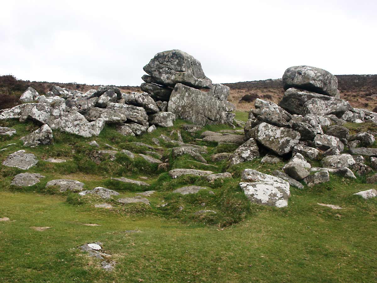
Photo 2
Grimspound's perimeter wall
Upon approaching Grimspound, the first structure you will notice are the remains of the perimeter wall as shown in photo 2, consisting of vast numbers of randomly sized granite stones scattered along the line of the wall which in some places amounts to more than 15 feet in thickness.
In some places it is still possible to detect some order in the placement of the stones, although there is probably no way now of knowing whether this is the original wall structure or whether it is the result of work done during the aforementioned 1894 to 1896 excavation, when parts of the wall were known to have been rebuilt. In some areas it looks as though the wall may have consisted in fact of two separate walls about 3 feet thick with a gap between of a similar thickness, although the subsequent collapse, a bit of a mystery itself for such a massive structure, has made this difficult to determine.
I am aware that the site has been visited by various people expert in the art of dowsing, and claims have been made that there are two dowsable lines running down the line of the wall lending weight to the cavity wall theory, although my sorry attempts at the art produced no repeatable results.
The Devonshire Association 1894 (Vol.26), page 113
The Committee further proceeded to investigate the wall of the enclosure. This is in a condition of sad, and at first sight, inexplicable ruin; but the wrecked condition of the wall presents some significant and instructive features. In several places two faces, one outer, the other inner, remain comparatively perfect, showing that the wall originally did not consist of a congeries of stones piled together at random, but was composed like the hut walls of stones, some set on edge, and of others laid in courses.
- Baring-Gould, Burnard, et al (1894)
The Devonshire Association 1895 (Vol.27), page 82
The Committee are obliged to admit that the structure of this wall is difficult of interpretation. At base the heap of ruins that forms the wall measures, where two faces remain undisturbed, about 12 feet. On examination of the wall, in eleven different places, it became apparent that this wall consisted originally of two, with a space between them of 3 feet 6 inches in width, or thereabouts, sometimes a little less, sometimes more. In places there seemed to be an inner face, on both sides, to this space.
- Baring-Gould, Burnard, et al (1895)
The wall was presumably constructed as a long-term plan to keep the predators of the time (wolves & bears) from entering the enclosure, but it would have been quite easy for them to climb an ordinary low wall. Perhaps this was why it was constructed using an inner and outer layer, to create a void over which animals may not wish to pass, although I can't see it deterring something as agile as a wolf. Perhaps there was a wooden palisade above the wall, with the poles anchored in the ground in the space between the two walls, which would have been far more effective.
There are some unexplained but interesting structures present at the western side of the enclosure, indicated on my map by the two parallel lines of stones just below where the Headland Warren path breaks the wall, and I've been able to dowse several linear structures coming in perpendicularly for perhaps 15 feet from the outer wall at intervals of about 10 to 15 feet below this point. I have no idea what they were, but possibly could have been animal pens or areas set aside for growing crops.
The Main Entrance To Grimspound
To the South East of the enclosure at the top end is an impressive entrance which was most likely the single original gateway to the pound, built using several very large stones and amounting to around seven feet in width, although I was interested to note during my research that in some of the early descriptions of this site, this most obvious and visible gateway has been given little or no mention, this apparently because the entrance was in a poor state of preservation at the time.
The Devonshire Association 1894 (Vol.26), page 116
This (the entrance) was much encumbered with fallen stones, which the Committee proceeded to clear out, when the entire entrance was revealed in its original condition, paved throughout, and with steps in the floor. It is 7 ft. wide, and the wall at this point is 14 ft. thick.
- Baring-Gould, Burnard, et al (1894)

Photo 3 |

Photo 4 |
The villagers would probably have taken their livestock through this gateway up onto the hills during the day to graze, and would have returned them to the enclosure at night to avoid losing any to marauding wolves. The floor of the gateway is paved with large flat granite slabs which are visible in photo 3, presumably to avoid erosion, and there is evidence of three large steps being placed just inside to help reduce the severity of the drop in ground level upon entering the pound, evidence of the steps still visible in photo 4. Once all the animals and villagers were safely inside, a wooden gate would probably have been drawn up and lashed into place across the gateway to secure the community against the threat of the wild animals.

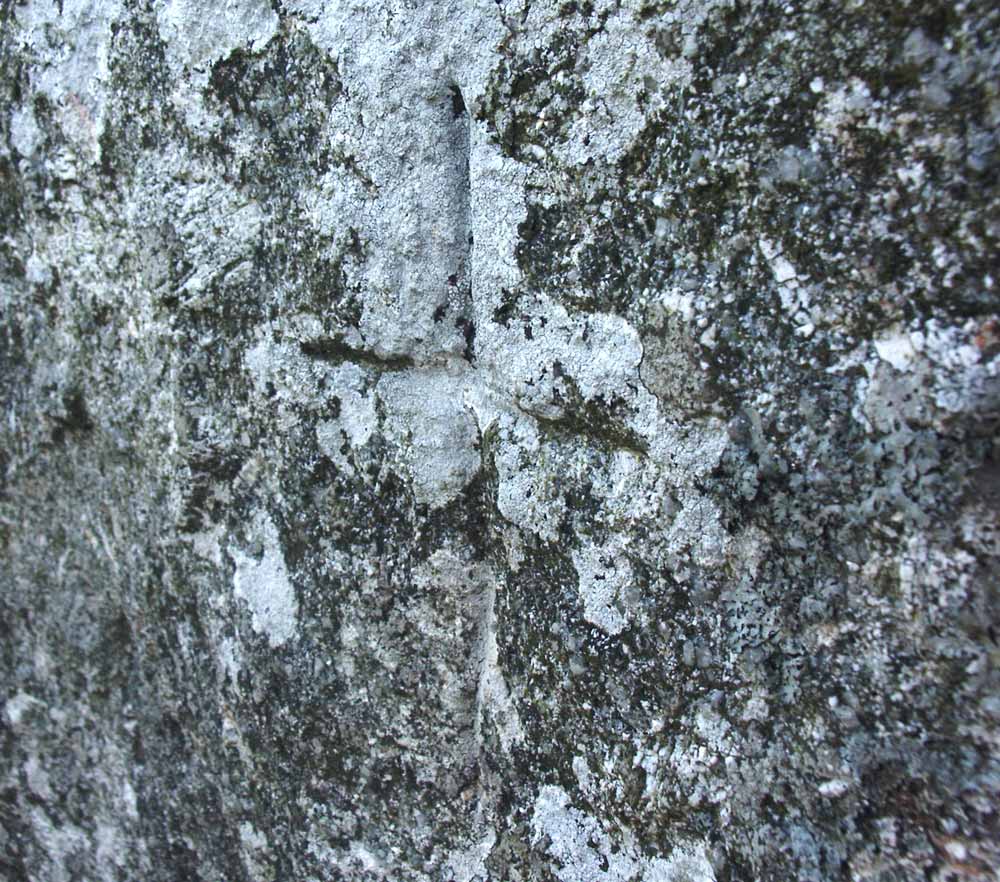
Photo 5
Carved cross on an entrance stone
One interesting feature I noticed while examining the entrance stones at Grimspound was the presence of a small cross about 6 inches in height carved into the granite to a depth of 5 to 10mm. It is located on the middle stone of the entrance wall on the left hand side as you face outwards, and the cross itself is shown in photo 5.
Although I doubt very much that the cross dates from the time of occupation, it is fairly old as lichens have grown over and into the carving in the same manner and to the same extent as on the rest of the stone, and lichens, especially in this environment are quite slow growing.
The carving itself also seems to have suffered from the effects of weathering to some degree and doesn't have the sharp edges of a freshly-gouged carving; granite is a hard rock and it would have required something sturdier than just a pen-knife to carve this into the rock, suggesting a hammer and cold chisel. I have examined other stones around the site but as yet haven't found any other carvings or inscriptions.
The Dartmoor Exploration Committee spent quite a while clearing away rubble and examining the main entrance to Grimspound during their exhaustive survey of the site in 1894, but nothing about the cross was mentioned in their report; I believe it would have had a mention had it been there so it's reasonable to assume that it has appeared since then.
If you have more than a passing interest in Grimspound, I'd recommend reading through the reports of the Dartmoor Exploration Committee, which were published in the Devonshire Association 1894 and 1895.
The Hut Circles
Within Grimspound itself can be seen the remains of the many dwellings and storage huts, manifesting themselves as roughly circular structures between nine and fifteen feet in diameter consisting of large granite boulders lying embedded in the ground. Eighteen of these hut circles were altered to some degree during the 1894 - 1896 excavations, as they were dug up and in some cases fallen boulders were returned to their supposed correct positions. Of the eighteen huts that were excavated, it is understood that thirteen were found to show evidence of having been lived in, the remainder apparently of simpler construction and so maybe only used for storage.
The construction of the inhabited huts mostly seems to follow the same basic style and pattern, with an entrance passage leading to a paved doorway constructed using two uprights supporting a lintel, inside there being evidence of a raised section which could have been used as a bed area to minimise the effects of damp, where bedding material made from old skins, dried grass and so on may have been used to enhance comfort and help keep the occupant warm.
A hearth stone is also present in some, but by no means all of the huts lending weight to the idea that some were used for storage only, and the remains of fires have been identified although without the benefit of carbon dating we don't know if these burnt remains are the results of more recent occupation. The walls of the huts would have stood perhaps 3 feet high and it has been reported that in some cases they seem to have consisted of a double row of stones, so it is possible that vegetable matter or soil would have been pushed between the stones for wind-proofing and insulation.

Fig. 3
Sketch of the features uncovered in hut 3
Fig. 3 shows the internal structures of a typical hut, this one being hut 3 which was considered to be the best preserved. Note the curved passage leading to the doorway, and the raised 'dais' at the top of this image, which may have functioned as both a seat and a bed.
- Image source: The Devonshire Association 1894, page 108a.
How the roofs of the huts were constructed is unknown as there is no trace of any wooden remains anywhere on the site, as you may expect. We can, however make some sensible guesses as to the form a roof could have taken based on results of surveys on similarly aged sites. Most likely in my opinion it would have been constructed from a framework of timbers set to a central pole with simple thatch tied over the top to waterproof it and probably a small ventilation hole being left in the roof to allow smoke to escape. Quite how such a roof was persuaded to stay on is also a subject for guesswork as during one of my visits there was a gusty 25mph wind blowing from the west, so some serious lashing down must have been in order.
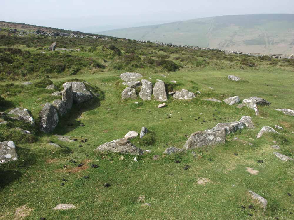
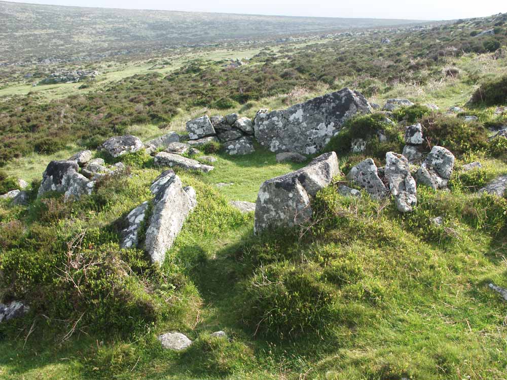
The following four photos show some of the hut circles at Grimspound, in varying degrees of decay but typical of what remains now. Some may have been damaged during research, others may have been partially 'repaired'.

Photo 6 |

Photo 7 |

Photo 8 |

Photo 9 |
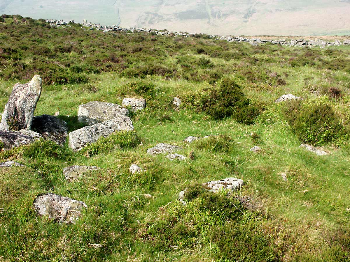
A total of 24 circular stone structures have been officially identified within Grimspound although I personally believe there to be at least two more, and there are many loose rocks apparently strewn at random about the site suggesting other as yet unidentified structures. Several more hut circles can be found on the south side of the hill leading up to Hookney Tor, and presumably these were connected in some way with the main village. I have seen suggestions that low-ranking villagers might have lived in the dwellings outside the pound, with just the more important living within the perimeter.
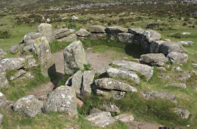
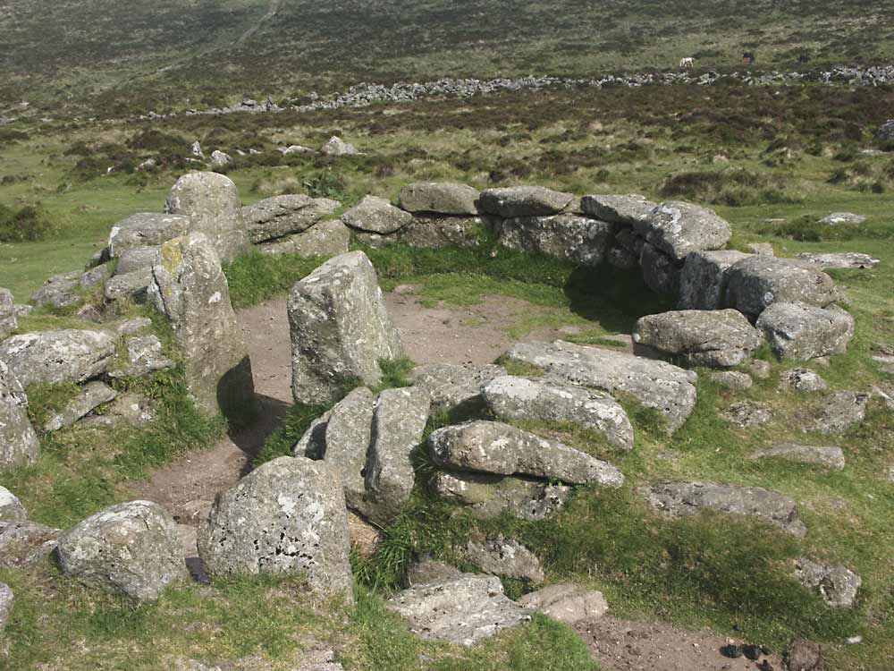
Photo 10 |
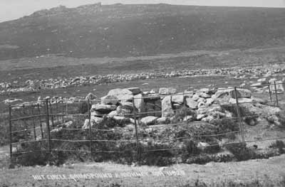
Photo 11 |
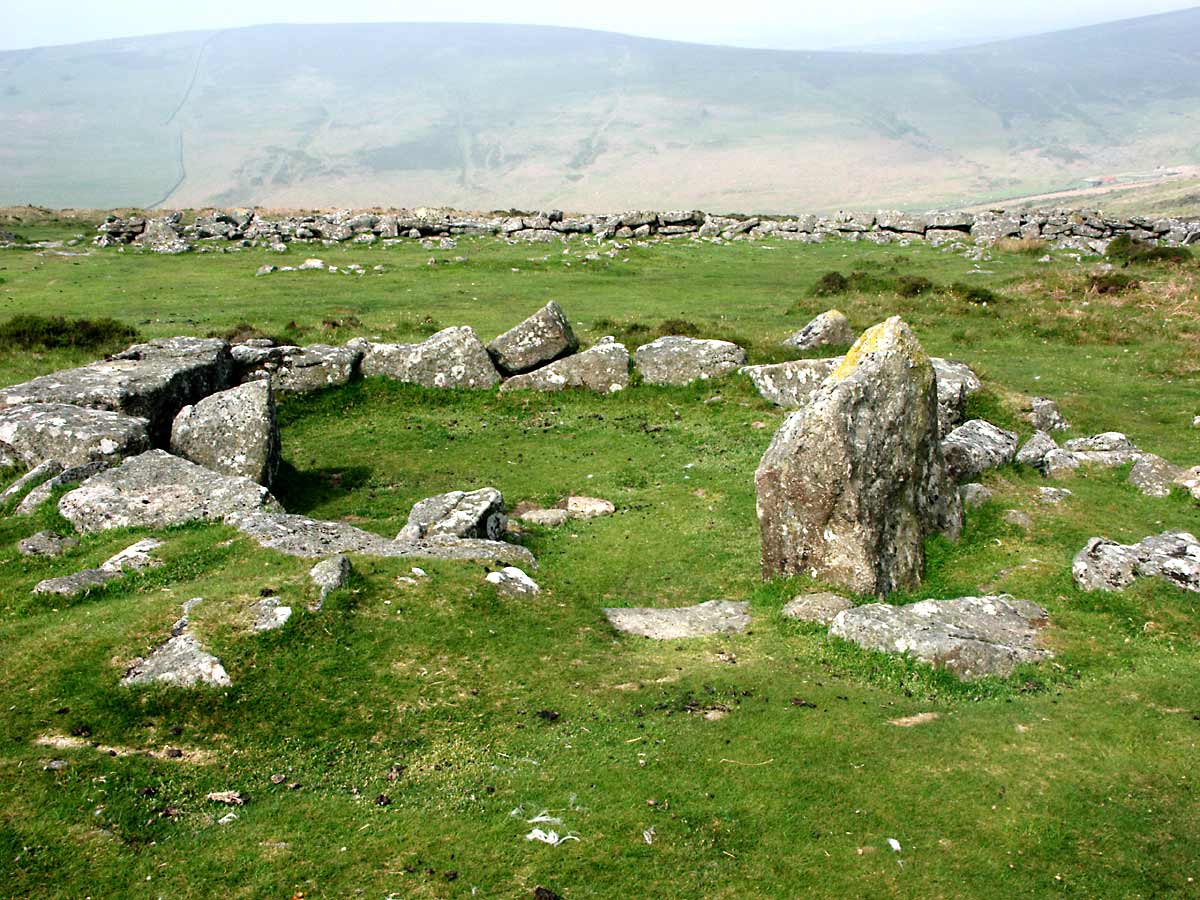
Photo 10 above shows hut 3, which is of particular interest as it was 'restored' during the 1890's excavation and had its walls rebuilt.
Photo 11 is my reproduction of an old postcard in my possession, published by Chapman & Son of Dawlish. This shows the iron railings that had been installed around the restored hut circle to keep moorland livestock at bay.
The Devonshire Association 1894 (Vol.26), page 109
Owing to the remarkable condition of preservation in which this hut was, the Committee resolved to re-construct the walls where fallen, to bank them up with turf, and then to enclose the whole with iron hurdles and to leave the floor exposed, with hearth, dais, and cooking hole, for the enlightenment of visitors interested in the pre-historic antiquities of Dartmoor.
- Baring-Gould, Burnard, et al (1894)
The stone circle has now started to fall into disrepair again and as the iron railings have long since been stolen, sheep have had access to the remains with the resultant erosion, although human visitors have probably also contributed to the damage; hut 3 is, however, still the best example of how these dwellings may have once looked.
I imagine that besides the more robust stone huts, there were originally also extensive timber structures here, taking the form of fenced paddocks to separate livestock, store rooms annexed to some of the huts, workshops and maybe several wooden dwellings in addition to the stone ones. A large portion of the enclosure seems to be devoid of any remains, and it is possible that this area had once contained wooden structures long since rotted away where perhaps the less affluent members of the community lived, with the more permanent stone huts being reserved for skilled craftsmen or leaders, but ultimately we can only guess how this dwelling would have looked, and what life would have been like here.